Introduction
Modernism urban design is an urban design approach that is developed in the modernism era. Being the first doctrine of urban design developed after the industrial revolution, modernism has many characteristics, good or bad, that is still affecting the cities’ planning nowadays.
Two of the characteristics will be discussed in terms of city transportation. This blog is targeted to discuss the application of modernism doctrine in modern society and to share the process while analyzing the application of modernism in a specific city. And, the importance to think critically in the subject of urban design.
About Chandigarh:
Chandigarh is a relatively new city compare to the history of India and large cities like Bangalore, the construction of the city began in the early 1950s. After the partition of the British Raj, the province of Punjab was divided into two parts. The province capital went to Pakistan and the eastern part went to India. Thus, India’s Punjab province requires new capital. Also, the great amount population in East Punjab is lacking education and sanitation resources including schools and hospitals. Thus, Chandigarh is expected to be not only a political center but also a city capable to resettle thousands of refugees.
Chandigarh is a planned city. Before the construction, only several villages were in this region. Thus, a detailed plan can be put into action with little resistance. Le Corbusier and Albert Mayer designed the city. And this is one of the very few cities that was completely designed out of the modernists’ hand. Thus, it is considered as one of the numerous urban planning schemes of Le Corbusier to have been executed. Thus, Chandigarh is a suitable example that illustrates the concept of Modernism.
Design of Chandigarh and its advantage:
Considering the great number of refugees and their poor financial condition in East Punjab, each of them will need a stable job to survive. And factories are one of the buildings that can provide the most jobs. Besides this, the Indian government directly ordered industries to be part of the urban plan; the majority of them are light industries and some of them are heavy industries, for example, the Ordnance Factory Chandigarh which is affiliated with the Indian Military.
To accomplish these effects, the areas in the city are selectively designed to specialize in one task. In Figure 1, the yellow region indicates the industrial phase I – III. However, this is a master plan for Chandigarh in the 2030s. Back in the 1950s, only the industrial phase I was designed. Thus, only phase I will be analyzed.
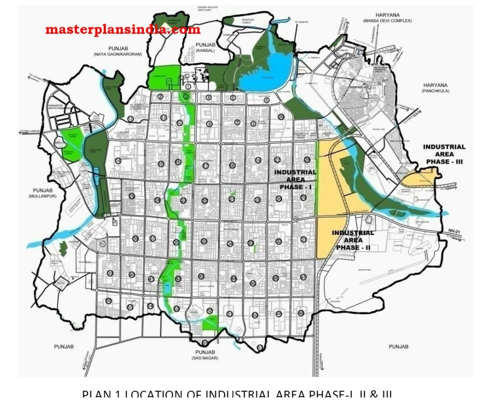
Figure 1: The Industrial Area Phase I – III in Chandigarh (India masterplan).
In the 1900s, for old European cities like London, it is noticed that the traffic is under great pressure. There are many reasons for this phenomenon. And one of them is closely related to the industrial revolution. The factories under the concept of mass production can produce an unimaginable amount of goods, together with the demand of an equally unimaginable number of resources. For old cities, the factories are distributed throughout the city. Thus, it is predictable that the huge number of products and resources for factories capture roads’ majority capability. Even though the cargo trucks that appeared in the 1920s improved this condition by a bit, the traffic is still under great pressure.
The first step of the most effective set of solutions is to integrate all the distributed factories into a region of the city so that the products and resources will not capture the majority of the city’s transportation capability. However, this method alone will only concentrate the traffic pressure from the entire city to a tiny region in the city and greatly pressurize that tiny region even more. The second step is to move the region to the edge of the city. This theory can be explained with the help of Figure 2.
In Figure 2, the industrial area is located in the center of city. First, it is suggested to recognize the play and role of cities. Cities tend to consume resources, whether it is a natural resource extracted from ore stations or it is a semifinished good from another city, and output a great amount of product that well above the needs of itself. Thus, it is suitable to assume that most resources are from the outskirt and most destinations of the product are other cities. In Figure 2, four of the most significant logistics are included and they are the input of resources from the outskirt, the output of products to the outskirt, the distribution of product into the city, and the commute of workers. Among them, the input of resources and output of products will take the biggest share of transportation capability because they will require heavy vehicles like trucks which are slower and bigger compared to cars. Among the resources part and products part, the resources part will take more capability because a part of the products will need to be distributed throughout the city instead of going to outskirt. The shadow area indicates the urban region in which transportation is under extra pressure from resources and products. Besides the shaded area, the distribution of products and commute of workers will also put the city center’s traffic into its limit.
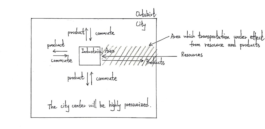
Figure 2: The diagrammatic sketch when Industrial Area is in city center.
If the industrial area is moved to the edge of the city, the area of the shaded region will be decreased as the industrial area approaches the outskirt. The city center is no longer pressurized. Workers and products can also travel along the ring road, for example, the London Orbital or Bundesautobahn 10 in Berlin, to reach the industrial area faster if the city is equipped with one.
The last step is to build a high-speed transportation network that is capable to function under great pressure near this industrial area, for example, railways and highways.
In terms of the concept from the three steps, Chandigarh’s design of the industrial area is considered successful. Factories are concentrated into an industrial area, and the area is located near the boundary of the city. Also, the major road NH-21 together with a railway from Punjab to Haryana runs through the industrial area.
Design of Chandigarh and it’s weakness:
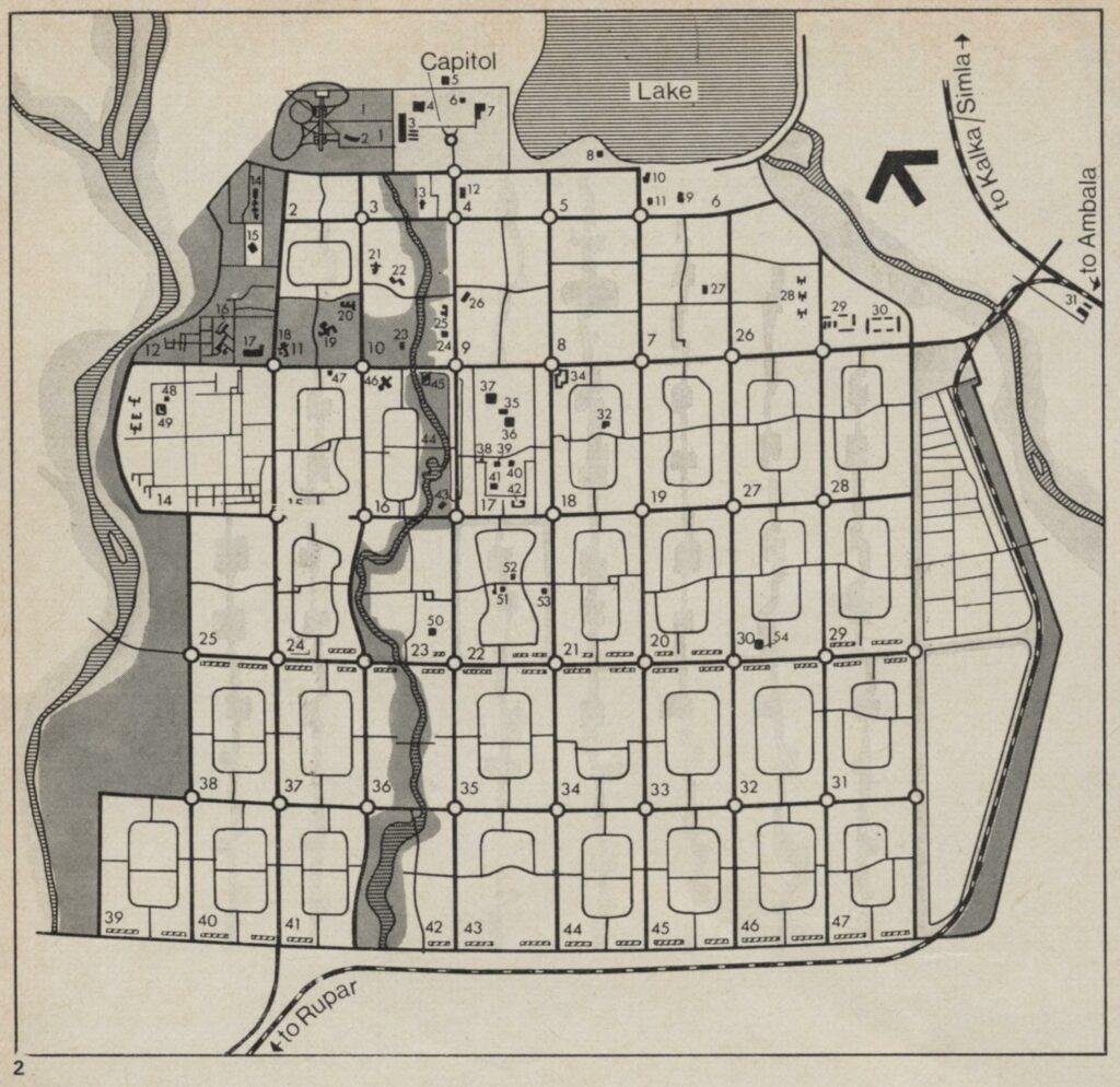
Figure 3 The planning map of Chandigarh (Chandigarh: a memorial to arrogance, Gethin).
Considering the city built for thousands of refugees, the city’s residential area is designed under a scheme of high-density. Figure 3 is a planning map of Chandigarh and it is obvious to notice that the city is made up of small, close-packed blocks. These blocks are called “superblocks” or sectors. And every sector has a similar layout. The detailed layout of a sector is displayed in Figure 4.
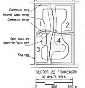
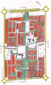
Figure 4: The concept of one superblock (Chandigarh Urban Planning Concepts, Avasak).
In Figure 4, there are “commercial strips” around the edge of the superblock and a “commercial street” that is in the center of it. These are the places where small commercial areas will be built which are responsible for supplying the entire superblock. In order to further analyses the superblocks, the commercial areas have to be discussed first; just like the factories are analyzed before discussing the industrial area.
There is one similarity between a small commercial zone and a factory; they all require logistics and are heavily dependent on transportation. That is, commercial zones will tend to create a lot of traffic and if congestion takes place for a long time near the zone, the activity of the commercial zone is negatively affected.
However, the initial planning of the superblocks wasn’t able to realize how enormous the scale of logistics is nowadays. And the layout of “commercial strips” and “commercial street” inside one superblock is a burden on both the commercial zones of this block and the roads in the neighbor of the superblock. This can be analyzed in three aspects.
The first aspect focused on the interior of a superblock. Considering the trucks and other large vehicles are required for logistics, the commercial zone also needs a considerable amount of time for each vehicle to stop and discharge their cargo. Since the commercial zone is just next to the “commercial street”, the vehicles have no choice but to park by the roadside. This phenomenon will exert a negligible effect on the street in the 1950s. But as the internet of things developed, more and more vehicles are demanded by the commercial zone; congestion will tend to form inside the superblock as vehicles keep parking by the roadside.
The second aspect will further develop based on the first one. There are only four entrance/exit for the entire superblock. Figure 5 is a picture from Google Map for Sector 35 in Chandigarh; as labeled on the figure, it only has 2 major entrance/exits and 2 minor exits together with 4 other tiny entrance/exits (the 2 major entrances are selected based on bandwidth). This means if congestion happens on one of the major or minor exits. Nearly of the total traffic will have to be detoured to other entrance/exits or terminate. Private cars can detour by driving into branches like the internal looped street in Figure 4. However, the cargo trucks will have to wait, because the place where congestion happens is likely to be its destination; if the congestion is caused by the discharging of other trucks during traffic peak time.
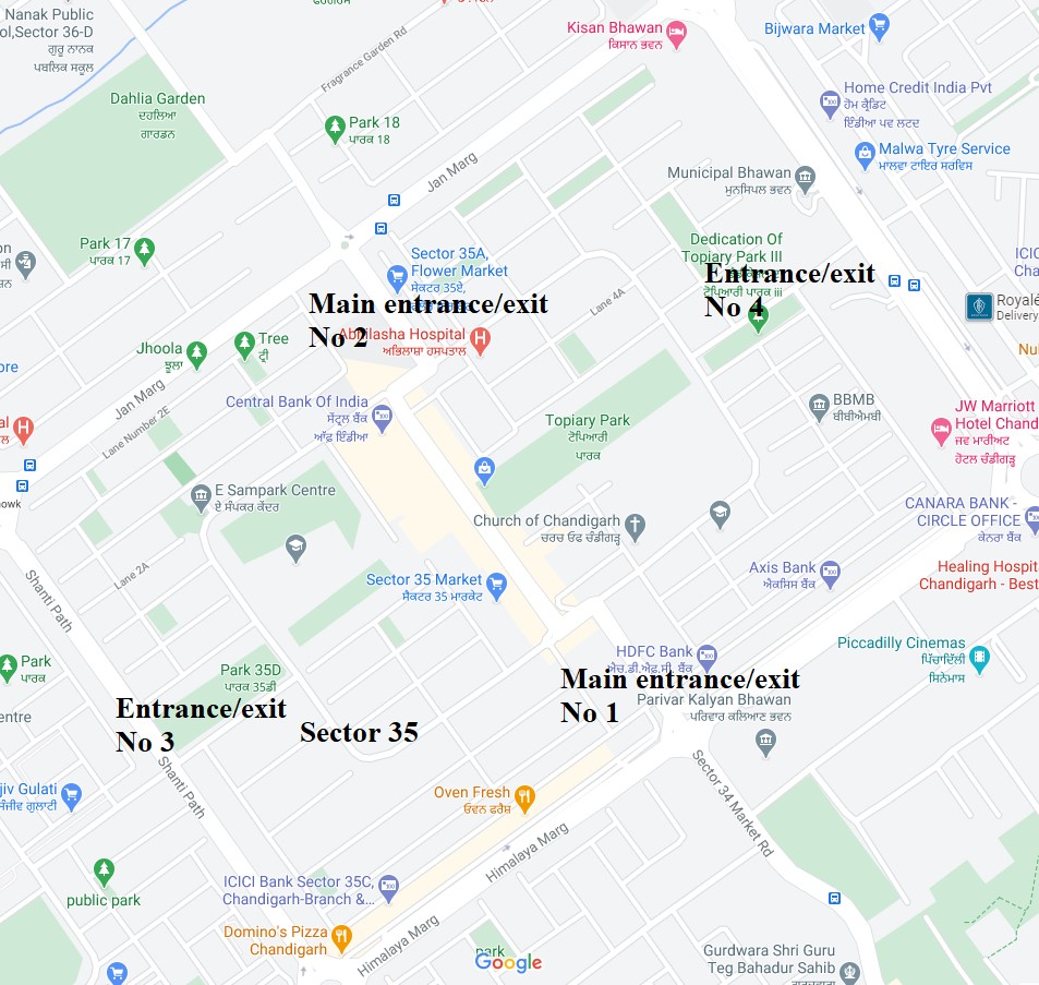
Figure 5: The Sector 35 and its four entrance/exit (Google Map).
The third aspect focuses on the connection between the superblocks and inter-sector roads. The inter-sector roads are the highways in Figure 3 that go through the entire Chandigarh city. This aspect is a graduate process, in order to describe it, a series of diagrammatic sketches are needed, and they are Figure 6, Figure 7, and Figure 8.
It is assumed that congestion appears inside one superblock, as shown in Figure 6, the reason may vary; probably it is due to the discharging of cargo as described in the first and second aspect or else. Because the internal of the superblock is directly connected to the highways by the entrance/exits shown in Figure 5. Internal congestion will force all vehicles in the entrance/exits to form a line, if there are sufficient vehicles, the line will be long enough to approach the horizontal highway in Figure 6.
The vehicles in the horizontal highway can be concluded into two categories, the ones which will continue to drive along the highway and the ones which will turn and drive into the congested superblock. The ones in the first category can continue smoothly, however, the ones in the second category are forced to wait behind the congested line. Thus, as cars accumulate, cars will accumulate fast because this is a highway, a bottleneck will form in the middle of the highway and it is shown in Figure 7.
The bottleneck will considerably decrease the vehicles’ velocity nearby. However, the velocity very far from here is barely changed. Thus, as long as the congestion remains, the bottleneck will grow in size, and further decreasing the vehicles’ velocity. Then, as shown in Figure 8, when the shaded area — the bottleneck– is approaching the crossroad, the vehicles traveling in the vertical direction will also feel the resistance; because the crossroad is a roundabout (it is not drawn in the diagrammatic sketch Figure 8). In a roundabout, vehicles from all directions are expected to encircle constantly together; if there is a bottleneck in the horizontal direction, the velocity in the vertical direction will also be affected.
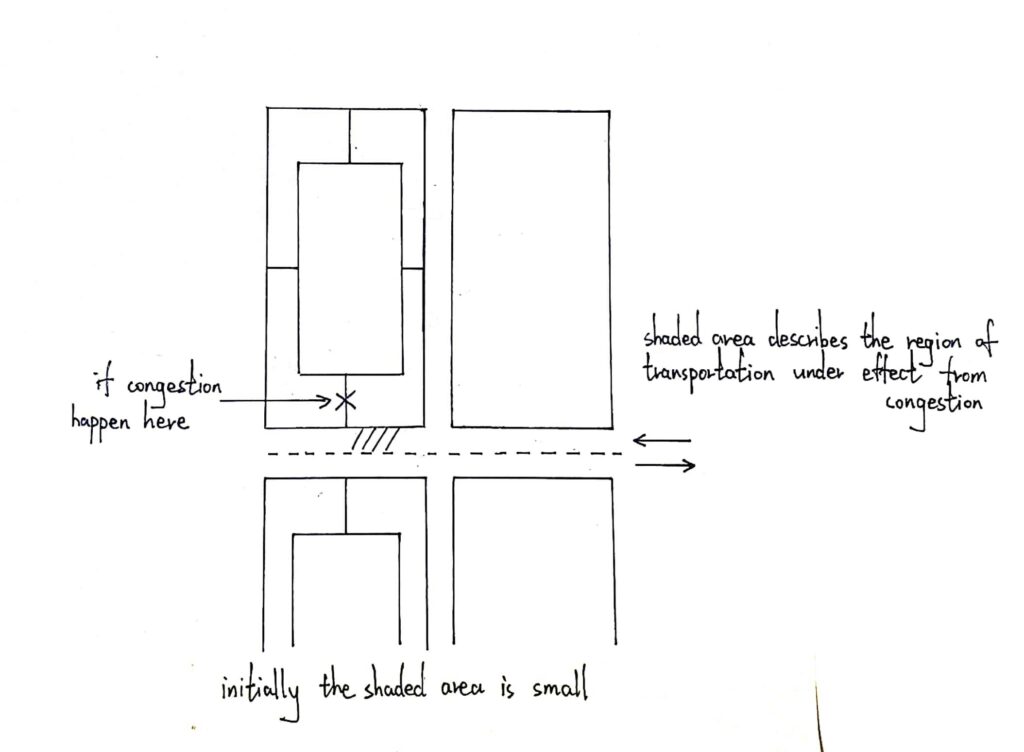
Figure 6: The initial phase of congestion.
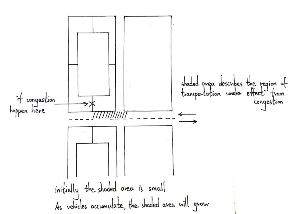
Figure 7: The developing phase of congestion.
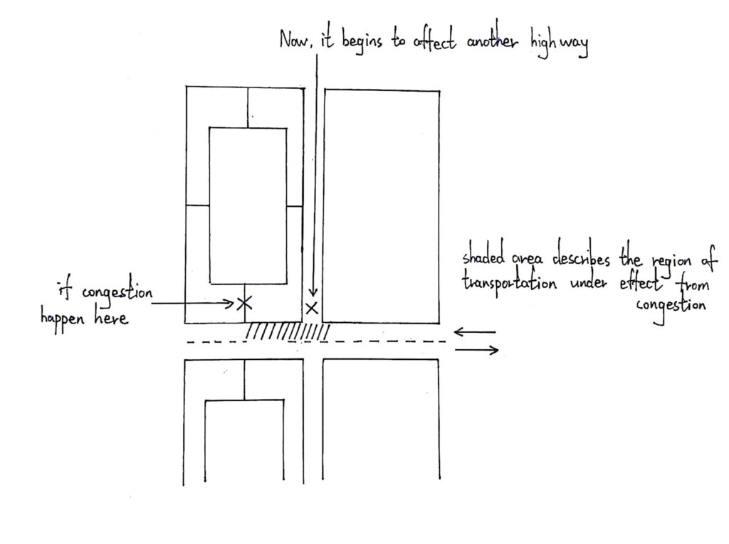
Figure 8: The spreading phase of congestion.
Nowadays, the road condition in Chandigarh is not in a good shape. Considering it is a relatively new city in India, Chandigarh is one of the most congested cities in India. Figure 9 shows the ranking for the 20 most congested cities. However, Chandigarh is a relatively new city, it is not yet overpopulated. Thus, Figure 10 also lists the population density of all 20 cities and is arranged in descending order.
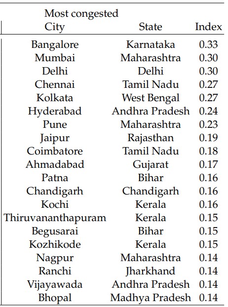
Figure 9: The ranking for 20 most congested cities in India. (Mobility and congestion in Urban India, Akbar)
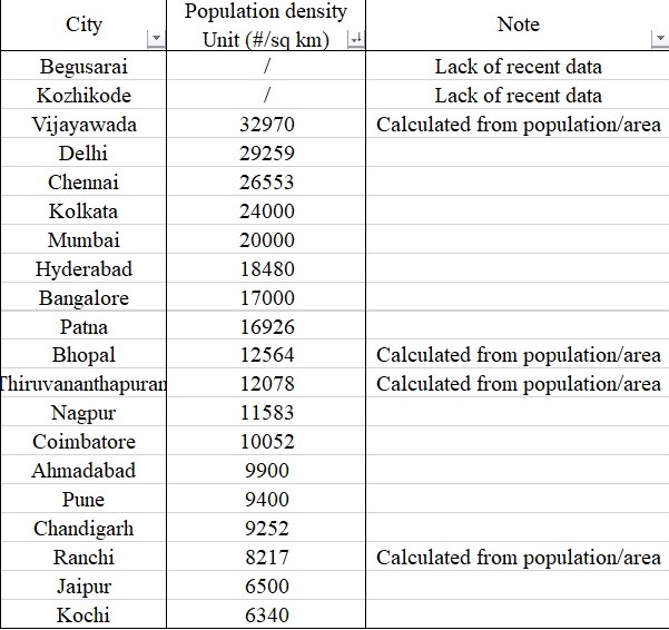
Figure 10: The ranking for the 20 cities in population density.
Because Begusarai and Kozhikode are lacking recent population data, the comparison is only between 18 cities. Among the 18 cities, Chandigarh is the 15th most populated city; but it is the 12th most congested city. This indicates that Chandigarh is very congested among all cities if all cities have the same population density. It is mentioned again that Chandigarh is a relatively new city in India and it is anomalous for it to behave in this manner. One reason for this is probably because the superblock design has the above three aspects mentioned above which will potentially cause congestion.
Summary:
Critical thinking is always important. Yes, the concertation of the industrial area in Chandigarh has a huge advantage and the design of superblocks in Chandigarh to some extent has disadvantages. But, these never indicate the concertation of industrial area is always a good approach nor the superblock is always a bad approach.
For example, the concertation of the industrial area will make the city vulnerable to air or artillery strike, since a single precise explosion can detonate and wipe out most of the factories in this industrial area. However, this disadvantage is insignificant because the world is now in a relatively peaceful era.
Also, superblock design in Chandigarh is a disadvantage; one of the reasons for this is because superblock is next to the high-way. If the superblock is congested, the high-way will also be affected. Thus, if the road next to the superblock is not a high-way, then congestion that happened inside one superblock is likely to exert a much smaller influence. For example, if a city’s high-ways are all integrated on overpasses or underpasses. Then the superblock’s close-packed arrangement may value more as an advantage.
Reference:
Akbar, Prottoy, et al. “Mobility and Congestion in Urban India.” 2018, doi:10.3386/w25218.
Avasak, Gauri, et al. CHANDIGARH Urban Planning Concepts. landlab.files.wordpress.com/2011/04/chandigarh-qt8.pdf.
Gethin, Christopher. “Chandigarh: a Memorial to Arrogance.” Built Environment, vol. Vol.2, May 1973, pp. 291–294.
Rajkumar. Chandigarh Industrial Area Location Map, MasterPlansIndia, 19 Jan. 2014, www.masterplansindia.com/chandigarh-industrial-area-location-map/.
Tungare, Amit. “Le Corbusier’s Principles of City Planning and Their Application in Virtual Environments.” May 2001, doi:10.22215/etd/2001-04766.
Urban Planning, Chandigarh Administration, urbanplanning.chd.gov.in/index.php/home/page/20.
Cheng, I thought your blog post was really interesting. I knew absolutely nothing about urban design before reading, and I really liked how you gave a brief introduction about the city of Chandigarh and what the developers’ goals were in creating it. I also really liked how you went in-depth with the logistics of the traffic, and how the developers worked to reduce it by compartmentalizing the industrial sector (among other techniques). This is something I have never really thought about when walking around a city, and I wonder how many other cities employ similar traffic-reduction methods. In general, I also greatly appreciated the number of diagrams you included to help visualize the subject matter; I generally learn better with some form of visual aid so this definitely helped my understanding. Particularly, I enjoyed the diagrams showing how traffic accumulates; these were really neat and did a great job explaining the topic. In the end, I also thought it was intriguing how you considered the possibility of an artillery strike, which would no doubt be devastating to a concentrated industrial area. Even though we talked about WW1 in class on Monday, this was a disadvantage I had not considered, but now definitely recognize as a significant one especially in times of conflict.